South Downs history knowledge nuggets: Monarch’s Way
May 4, 2023
 Cultural heritage lead Anooshka Rawden takes a look at the history of this remarkable route.
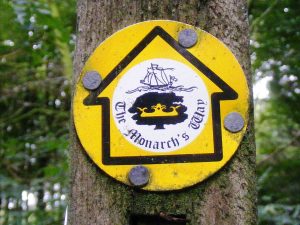
If you’re a regular walker across the South Downs you might occasionally see signage for the Monarch’s Way that cuts through places like Hambledon, Kingley Vale, Arundel and ends at Shoreham.
This is the fourth longest waymarked route in England, and broadly follows the route taken by King Charles II as he fled to France to escape the Cromwellian forces following his defeat at the Battle of Worcester in 1651. It’s over 600 miles in total, and charts around six weeks in history in which Charles was a fugitive within the Kingdom.
The battle was part of the ongoing struggle by Charles to reclaim the Kingdom after the execution of his father, King Charles I, in 1649.
His passage to France was masterminded by Colonel Gunter, of Racton, west of Chichester, who made arrangements for the King to be smuggled to France.
After being recognised in Brighton by an over-excited pub landlord, Charles eventually reached Shoreham and was transported out to France on a ship called Surprise – which is incidentally why there is a ship on the Monarch’s Way signs. There he was able to join his mother, Queen Henrietta Maria, living in exile since her husband’s execution.
It was not until after the death of Cromwell and the political disruption of the inter-regnum that Charles could plan a return to power.
He returned to England nine years later, having passed his time in exile in France and Holland, being crowned Charles II on 23 April 1661.
The Monarch’s Way wasn’t established until 1994 by a man called Trevor Antill, and its route was published in a three- volume guide.
If you’d like to find out more about the history there’s a really useful article here on the Ramblers website.
To find out more about the Monarch’s Way, including information on trail sections, visit www.monarchsway.50megs.com
